


Athens North Voting District, Gentry County, Missouri
About
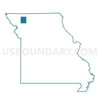
Outline

Summary
| Unique Area Identifier | 607856 |
| Name | Athens North Voting District |
| County | Gentry County |
| State | Missouri |
| Area (square miles) | 30.53 |
| Land Area (square miles) | 30.52 |
| Water Area (square miles) | 0.01 |
| % of Land Area | 99.98 |
| % of Water Area | 0.02 |
| Latitude of the Internal Point | 40.26311890 |
| Longtitude of the Internal Point | -94.30137910 |
Maps


Graphs
Select a template below for downloading or customizing gragh for Athens North Voting District, Gentry County, Missouri


Neighbors
Neighoring Voting District (by Name) Neighboring Voting District on the Map
- Athens South Voting District, Gentry County, MO
- Bogle/Gentry Voting District, Gentry County, MO
- Howard/Lone Star Voting District, Gentry County, MO
- Huggins/Carmack Voting District, Gentry County, MO
- New Hampton Voting District, Harrison County, MO
- Wesley Voting District, Harrison County, MO
Top 10 Neighboring County Subdivision (by Population) Neighboring County Subdivision on the Map
- Athens township, Gentry County, MO (2,178)
- White Oak township, Harrison County, MO (529)
- Dallas township, Harrison County, MO (218)
- Bogle township, Gentry County, MO (210)
- Huggins township, Gentry County, MO (146)
- Howard township, Gentry County, MO (100)